RGB Camera
Equipped with an RGB camera capable of capturing aerial imagery for orthomosaic mapping applications.
Industrial Drones
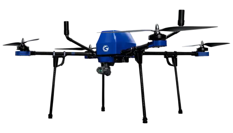
Product Overview
The 2D Mapping Drone (GA-IN-2D) from Garuda Aerospace is a precision aerial mapping platform designed to support industrial and enterprise survey applications. Integrated with RTK/PPK positioning, high-resolution sensors, and autonomous mission planning, the platform is designed to generate orthomosaic maps and terrain models. The system is designed to support reduction in survey timelines compared to conventional ground survey methods, reduce the need for personnel in hazardous survey areas, and enable efficient coverage for construction, mining, smart city, and infrastructure inspection projects.
Model Name
GA-IN-2D
Rated Payload (g)
200 grms
Gross Weight (kg)
4 kg
Rated Climb Rate
4 m/s
Rated Speed
10 m/s
Tested Endurance
40 mins
Rated Range
5 km
Operating Altitude
120 m
Dimensions
510*490*210 mm
Supports autonomous flight mission planning capabilities.
Equipped with aerial image capture at high resolution.
Designed to enable large-area mapping within a single mission cycle.
Incorporates obstacle sensing technology intended to enhance operational safety.
Offers flight control with waypoint-based navigation functionality.
Facilitates data acquisition for orthomosaic generation.
Supports survey-grade mapping accuracy utilising RTK / PPK technology.
Portable form factor designed for field deployment
Equipped with an RGB camera capable of capturing aerial imagery for orthomosaic mapping applications.
Integrated with a PPK navigation system intended to achieve centimetre-level geospatial accuracy.
Incorporates obstacle detection and avoidance sensors designed to support flight safety during operations.
Accelerated geospatial data collection over conventional methods
Accuracy compliant with prescribed survey standards
UAV-based data acquisition across project scales
Optimised field deployment with lower personnel risk